
VALID 12 OCT 2016
Straight Scoop (High Confidence):
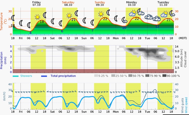
The unsettled weather and high winds of Tuesday will be replaced on Wednesday with more favorable conditions. Some cloudiness will persist over sections of the course (particularly the final portions into Mesquite) but the day will start with light winds and even a 5-8mph of quartering tail wind from the SE. The cloudiness will build as the day progresses, particularly in the Western portion of the course, and the chance of afternoon thunderstorms still exists. Overall, Wednesday should be a great day.
The series of short waves that dominated the weather on Tuesday is now down stream and the subsidence associated with the higher pressure now influencing the Southern Utah border will bring stable conditions.
The prospect of light tailwinds in the morning is probably not compelling enough to warrant an early start. This is particularly true given the potential for the next few days to be quite nice for racing. Winds will be out of the SE at 5-8mph early on and shift to 8-10mph after noon from the South.
Thursday and Friday also look favorable at this point. Both days will see light winds and mostly sunny skies but that will come to a close on Saturday when the next possibility of tighter pressure gradients exist.
Page to Mesquite Forecast:


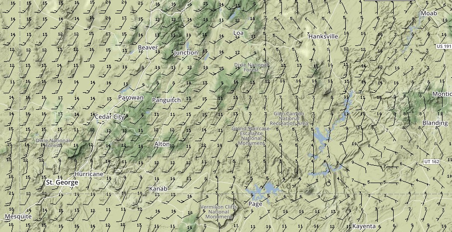
Tuesday – Saturday Meteogram (Kanab, Utah)

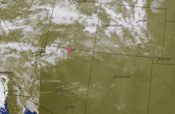
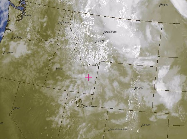
Composite VIS/IR Satellite Image Valid at 1630 Tuesday:
VALID 11 OCT 2016
Straight Scoop (Medium Confidence):
Tuesday will not be a total wash but progress won’t be as fast or as favorable as the past 4-5 days. There are several short wave disturbances that will bring clouds, precip and possible thunderstorms over the length of the Utah-Arizona border. Good Luck!!
There is a lot of uncertainty in the forecast models but it looks like there will be a good chance of relatively clear skies for the better part of the day. Intermittent precipitation will slow progress but for much of it, pilots will be able to avoid it by watching weather radar reports.
Despite the difficulties in early rising, starting as soon as possible on Tuesday will again be sensible as the winds will be 5-10mph from the SSW – the lowest you can expect to see for the day. Later on the winds will clock more to the SW and intensity, further slowing progress. By peak heating there will be localized thunderstorms with localized heavy precipitation.
For Wednesday, there is even more model uncertainty but it looks to be better than Tuesday with lower wind values and a decrease in the precipitation potential.
Monument Valley to Mesquite Forecast:

Monday – Friday Meteogram (Page, Arizona)

Composite VIS/IR Satellite Image Valid at 1730 Monday:
VALID 10 OCT 2016
Straight Scoop (High Confidence):
The amazing stretch of favorable weather is going to come to a close Monday night – particularly in SE Utah. There will be afternoon thunderstorm activity over the 4 corners region on Monday. On Tuesday, owing to both strong Southwesterlies peaking at over 25mph and widespread thunderstorm activity, good progress is unlikely.
Monday will start of very favorable for big gains and if you need a long flight to make goal, say from Moab or so, it would be a good idea to get an early start. The entire day will be useable but the winds will shift from Southerly or even a slight tail wind into strong Southwesterlies by the 1500. The potential for afternoon convection, particularly over the Western half of the state, will be moderated by some high cloud that will build to the North of the courseline.
After Monday, the outlook is not favorable again for a while because a series of small short wave disturbances. Tuesday the winds will be strong early (starting around midnight Monday) and range from 17-20mph with higher peak values in the afternoon. Spending too much time on Monday not making progress may significantly delay your arrival at goal.


Moab to Mesquite Forecast:
Monday – Friday Meteogram (Mesquite, NV)
Composite VIS/IR Satellite Image Valid at 1730 Sunday:
VALID 09 OCT 2016
Straight Scoop (High Confidence):
Sunday Morning will be a great day of racing. It is best to get an early start, though, because as the day progresses some moisture being brought into the region by a very weak system will bring afternoon thunderstorms at the extreme southern border of Utah. Winds remain light and the increase in instability will result in slightly higher turbulence. In summary – another great day Sunday.
Congrats to Dave! It looked like he enjoyed an amazing run downwind to goal. Well done. It’s amazing the variety in conditions that you have flown over the last week!
Early on Sunday along the course line south toward the UT border there will be a slight headwind coming nearly straight out of the south at 5-7mph. Winds remain light up to well over 14k so you can choose between flying high and fast or sight seeing at lower altitudes. The afternoon convection will start earlier than it did on Saturday but should not be a factor in the flats until near the border.
The tail wind that existed on Saturday will not help racers Sunday – it will remain SSW to SW all day along the border on the way to Mesquite. The models are in disagreement over the peak wind strengths but expect 5-7mph prior to noon and peaking out around 15-17 around peak heating. The chances for violent thunderstorms in the afternoon can not be fully ruled out tomorrow since there will be adequate moisture and instability.
Southbound Run Forecast:

6,000ft Winds at 0900: 6,000ft Winds at 1200: 6,000ft Winds at 1500:
Run to Goal:

Sunday – Thursday Meteogram (Provo, Utah)
Sunday – Thursday Meteogram (Mesquite, NV)

Composite VIS/IR Satellite Image Valid at 1730 Saturday:
VALID 08 OCT 2016
Straight Scoop (High Confidence):
There is not much reason to belabor the discussion: Saturday is going to be yet again better than the day before. The winds will be primarily out of the South around SLC but light all the way to well over 10k. There will likely be some high cirrus, which will cut down on the turbulence slightly and delay the onset of the afternoon thunderstorms – but not by much. Racers headed for the finish tomorrow will enjoy a tail wind en route to the beer and girls… or guys – whichever.
The weekend is going to be a great time it looks like and I am jealous that you will be able to enjoy excellent conditions to cap off the week. The 5-10mph head wind from the South around Salt Lake will not hamper progress appreciably, particularly given you can fly very high and fast. Heading deeper into the Eastern portion of the course to enjoy all the scenery will take longer but there is no risk of getting shut down due to weather because of taking a longer route. The shorter router (adventure course) will be fast and come under the influence of a 10-12mph tail wind once you turn West.
For Dave, and the leaders, it will be an amazing downwind run to all the glory and the festivities. The winds will be from the East at 10-12mph and the same turbulence concerns exist as the two previous days however the high cirrus may keep it moderated. No need to beat a dead horse – it should be excellent. Congratulations! Well earned.
Southern SLC Area Forecast

6,000ft Winds at 0900: 6,000ft Winds at 1200: 6,000ft Winds at 1500:

Saturday – Wednesday Meteogram (SLC, Utah)


Saturday – Wednesday Meteogram (Mesquite, NV)

Composite VIS/IR Satellite Image Valid at 1730 Friday:
VALID 07 OCT 2016
Straight Scoop (High Confidence):
Thursday marked the end of the transition into the amazing weather that can be expected for the next few days. Even Scotty will catch a break Friday after a very impressive push today. With high pressure dominating the weather, particularly South of SLC, expect clear skies until the normal afternoon convection over the mountains. Continue to be vigilant for the same type of thermic activity seen today – Huge bodies of water like the Great Salt Lake cut the turbulence factor but that doesn’t make it smart to fly over them further from shore than you want to swim an anchor.
The southern most racers are going to see nearly perfect conditions all day – light winds from the surface up to nearly 10 grand. What winds there are will mainly be driven by localized convection mixing with a prevailing flow of 5-10mph from the South at 6000ft. By 1100, thermic activity will reach 400-500fpm and at peak heating in mid afternoon expect 800-900fpm normal trigger points. The high pressure influence will make turbulence more pronounced with thermals having sharper edges than normal. If you can make it all the way to the southern extent of the course, there will be a tailwind of 10-12mph straight toward goal!
The story is very similar around Salt Lake City but the prevailing winds are slightly stronger due to the funneling against the Wasatch but only 10-12mph from the Southwest. Turbulence values will be similar as well compounded slightly by the higher wind values and more complex terrain. The risk of deflations is still far lower than the risk of swimming with a motor across a putrid, saline lake however. For Scotty, true to the spirit of what this race has thrown at him, there will be a headwind to contend with slowing his progress early on. The prevailing winds will be 15-17mph from the South between Idaho Falls and Pocatello but will gradually abate further south on the course line. In the early morning, cloudiness may persist around Idaho Falls but skies will be clear by Pocatello. From Pocatello to SLC, conditions are much more favorable and despite a 10mph headwind, conditions will allow for getting very high and making faster progress. Getting an early start makes sense to max out the day but keep in mind that temperatures near Idaho Falls will be below freezing through the night (NWS has an active advisory for crops in effect until mid morning Friday).
Leaders

6,000ft Winds at 0900: 6,000ft Winds at 1200: 6,000ft Winds at 1500:
Scotty's forecast
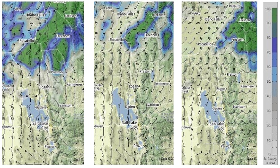
6,000ft Winds at 0900: 6,000ft Winds at 1200: 6,000ft Winds at 1500:
Friday – Tuesday Meteogram (SLC, Utah)

Friday – Tuesday Meteogram (Pocatello, ID)

Composite VIS/IR Satellite Image Valid at 1730 Thursday:
VALID 06 OCT 2016
Straight Scoop (Medium Confidence):
Maybe my call for Wednesday was a bit optimistic, but it seems everyone made good progress to within striking distance of SLC. The weather is going to continue to improve but expect lingering local showers, freezing rain and snow in isolated areas from Pocatello to Salt Lake City Thursday morning. Progress on the Northern portion of the course will be slow on Thursday and Friday if no progress is made Thursday.
For the main group, progress seemed good today despite the forecast being a bit off. Thursday will still be cold but not as bad as Wednesday. The promised high pressure and good weather heading into the weekend will become prevalent over the entire southern portion of the course. Look forward to highs in the mid 60’s by Friday! Sunny skies will dominate tomorrow afternoon – earlier closer to Salt Lake City. Winds will be light at the surface in the morning and at 6000 ft, they will be 10-12mph from the west. It will get slightly windier as the day progresses but never unmanageable. By noon, turbulence will be an issue, particularly closer to the Wasatch. Expect lift of 600fpm/3mps at noon and at peak heating, 1000fpm/5mps. Friday and Saturday will both be sunny from SLC to the finish but turbulence, particularly around the inversion height, will be a factor on both days. The turbulence will be worse over the race course than the adventure course due to the strong lapse rates.
Further North, the weather will not be as favorable for making progress. Patience will be required to make solid gains. The winds will be favorable when not being influenced by localized gust fronts associated with periods of precip. Early morning will be the best chance of a long flight and even at 6k, if ceilings are that high, the winds will be light. The day will begin to deteriorate by noon and grow progressively worse by mid afternoon. Temperatures will be significantly warmer on Friday (highs in the 50s) but the showers will persist if little progress is made on Thursday. If you can reach Dubois on Thursday, Friday will be favorable for racing. By Saturday, the race conditions will be much more favorable everywhere along the course.
Northern Portion:
Wednesday – Sunday Meteogram (SLC, Utah)
Wednesday – Sunday Meteogram (Butte, MT)
Composite VIS/IR Satellite Image Valid at 1730 Wednesday:
VALID 05 OCT 2016
Straight Scoop (High Confidence):
Huge gains will happen Wednesday with a stunning backdrop of snow in the mountains! The unsettled weather has dissipated quicker than expected and despite localized precip along the course, it should be a great day of racing provided you can overlook freezing your ass off. Thursday and Friday will be progressively even better.
For most the progress was good today given the conditions, it appears – even if that meant just successfully rebuilding your motor. Wednesday everyone should be able to get huge flights. Temperatures will remain way below seasonal average over the Rockies.
For racers further south, between Pocatello, ID and Logan UT, winds will be light and from the west but will build to 15-20 mph from W or WSW by 1000 at 6,000ft. Getting as far south as possible early will help avoid the increase in winds and also some moderate precip potential after 1200 around Logan. Once south of SLC, conditions will be excellent and will continue to improve for Thursday.
Further North near Missoula, (Scotty) conditions will be favorable once lingering precipitation dissipates and ceilings rise early on. By mid morning there will be a quartering tail wind of 5-7mph from the NW that will allow Scotty to get back into the mix. In the afternoon, the potential for precip exists and taking and line slightly further East of the courseline will mitigate that risk. There will also be a 10mph tail wind in the afternoon en-route to Idaho Falls.
Northern Portion

6,000ft Winds at 0900: 6,000ft Winds at 1200: 6,000ft Winds at 1500:
Southern Portion

6,000ft Winds at 0900: 6,000ft Winds at 1200: 6,000ft Winds at 1500:
Wednesday – Sunday Meteogram (Idaho Falls, ID)

Wednesday – Sunday Meteogram (SLC)

Weather Geek Stuff:
The pair of low pressure systems that made flying (and forecasting) tricky for Tuesday are now nearly dissipated and normal NW steering flow is the dominant feature. This NW flow a lot means temperatures will remain unseasonably cool and likely become even cooler on Wednesday. In the air, though, the flying will be more comfortable due to lower humidity and also periods of sunshine.
The NW flow is also brining stability into the entire Rockies region and the conditions will be increasingly favorable as the weekend draws closer. By Friday, it will be sunny and much warming as the region comes under the influence of high pressure.
Composite VIS/IR Satellite Image Valid at 1830 Tuesday:
valid 04 oct 2016
Straight Scoop (High Confidence):
The NWS Winter Weather Advisory issued for Monday remains active over the course line through Tuesday evening. Snow accumulations will reach 8 inches total above 7500’.
While the advisory sounds dire, there will be significant opportunities to make progress on Tuesday and the weather will continue to improve as the week progresses. Westerly Winds will begin to be a factor starting Tuesday afternoon South of Idaho Falls.
The fact that forward progress was made today by some pilots is impressive! On Tuesday progress will be slow but much better than Monday. The snow level will drop as low as 4,000ft on Monday night into Tuesday morning but precipitation will trail off as the morning progresses. Expect precip to get heavier again in the later part of the afternoon locally on Tuesday. Once the low that has been driving the weather is kicked out, the higher pressure will bring clearing and better conditions as the week progresses.
Expect low ceilings – particularly in the early morning but those will rise as the day develops and all pilots should be able to make progress, possibly during intermittent periods of precipitation, toward Idaho Falls. Approaching Idaho Falls, be mindful of building Westerlies which will approach 25mph. North of there, winds will remain manageable for the entire day.
6,000ft Winds at 0900: 6,000ft Winds at 1200: 6,000ft Winds at 1500

Monday – Saturday Meteogram (Butte, MT)
Weather Geek Stuff: The cut off low that brought the bad weather Monday will slowly start to eject from the course line. There will still be areas of precipitation due to the lingering instability and the moisture brought into the region from the South by the upper level trough that was upstream over the weekend.
The weather will remain unsettled Tuesday but ridging will bring stability and increasingly more favourable sky conditions as the week progresses. Winds will begin to play a factor in decision making as the pressure gradient tightens further South on the course.
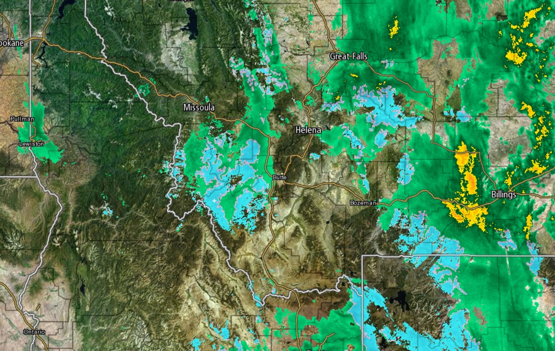
Composite Radar Image Valid at 1530 Monday:
Valid 03 OCT 2016
Straight Scoop (Moderate-High Confidence):
The NWS issued a Winter Weather Advisory for snow accumulation of 6 inches above 6000ft along the course line. The further west of I-15 you are, the worse it will be.
Overnight Sunday night will have periods of drizzle though drizzle will begin to influence the race. By morning, it is unlikely that there will be more than momentary periods to make progress south.
Everyone made good progress along the course on Day 1 and that is a good thing because today will likely see little or (more likely) no progress. A low pressure system which is influencing the weather and bringing periods of heavy rain below 6,000ft starting in the middle of the night Sunday night. Two areas in particular will be heavily affected – the Anaconda Pintler Wilderness area. West of Butte and 200km further south near Challis, ID. Above 6,000ft, there will be snow showers and eventually heavy snowfalls above 8,000ft.
It is possible that there will be short duration periods that will allow intermittent progress for pilots travelling the 1-15 corridor near Garrison and Deer Lodge. While this is rather unlikely, if it materializes, the winds will cooperate and there will be a 5-10kt tailwind.
The pilots who followed the I-15 corridor may get lucky – if you can fly, staying as East on the course line as possible will bring the best chances for modest progress.
Monday – Friday Meteogram (Butte, MT)
Weather Geek Stuff: The low pressure that is affecting the weather over the forecast area is separated from the upper level steering which is not good news. This low will be persistent since it is no longer under the influence of the upper level jet. Ceilings will likely be low for the remained of the week with most of the passes seeing obscuration over lengthy periods. Fortunately, most of the precipitation will fall Monday (both rain and snow) and Tuesday should offer more racing.
As the week progresses, the weather will remain unsettled but grow progressively better.
Composite Satellite Image, Valid at 2330 Sunday:
Pre Race OUtlook
Valid 01 OCT 2016
Straight Scoop (High Confidence):
Shake out your kit Saturday night and early Sunday – Day 1 needs to be a race day so fly as far as you can. Monday will be spent in the bars - Missoula unless you push.
Conditions change rather rapidly up here...
The lingering clouds and moisture from Saturday over Flathead Lake will likely mean early morning fog to contend with, but there should be plenty of opportunity to make solid distances Sunday. The winds will generally be light on the Northern portion of the course at lower elevations and build to light Easterlies above 4,500 ft. Higher, the winds will shift more southerly, impeding progress, but not terribly (10-12mph at 8k).
After re-fueling in Missoula, it will make sense to pay close attention to the cloud heights to the ESE. The winds around Missoula will be favorable for much of the afternoon but keep in mind if you are going to try to push through the I-15 corridor into Clinton (Sorry, couldn’t resist), there will be funneling and a good chance of low ceilings – and certainly a headwind.
6,000ft Winds at 0900: 6,000ft Winds at 1200: 6,000ft Winds at 1500
Saturday – Wednesday Meteogram (Missoula Area)
Weather Geek Stuff:
There is a large cold front dominating the weather for Saturday and into Sunday over ID and western MT. Behind the front, there will be some instability and clearing that will allow for decent flying conditions Sunday. An upper level trough is pulling a substantial amount of moisture into the area that will affect the early part of the week. There is some disagreement in the models beyond Monday but that should start to clear up by Sunday.
Water Vapor Composite Satellite Shot at 1200 Saturday
